PT Widjaya Global Services

DJI MATRICE 400

Long-Endurance Drone Platform With Power-Line-Level Obstacle Sensing

DJI Matrice 400, platform drone flagship kelas enterprise, menawarkan waktu terbang hingga 59 menit, kapasitas payload hingga 6 kg, serta LiDAR berputar dan radar mmWave terintegrasi untuk pendeteksian rintangan hingga level kabel listrik. Platform ini juga mendukung sistem O4 Enterprise Enhanced Video Transmission dan Airborne Relay Video Transmission, yang memungkinkan pengendalian lebih aman dan pengoperasian yang lebih mudah. Dengan mengombinasikan Smart Detection berbasis kamera visual dan termal, proyeksi AR, kemampuan lepas landas dan pendaratan di kapal, serta otomasi tingkat lanjut, Matrice 400 dirancang untuk mendukung kebutuhan respons darurat, inspeksi jaringan listrik, pemetaan, dan aplikasi AEC

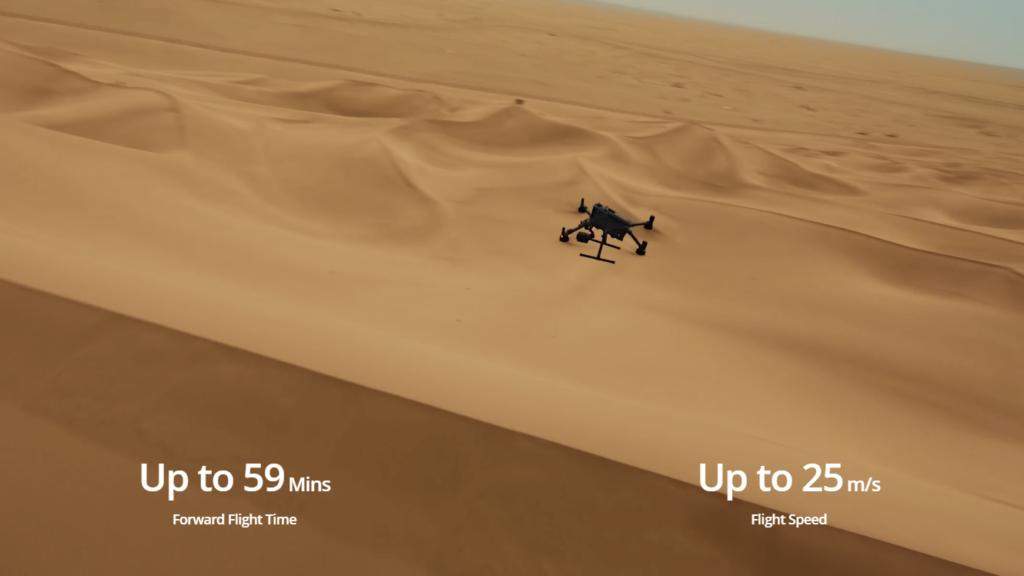
Waktu Terbang Panjang, Performa Tinggi

Matrice 400 menawarkan waktu terbang hingga 59 menit dengan payload dan waktu melayang hingga 53 menit, sehingga cocok untuk operasi berdurasi panjang seperti SAR, pemadaman kebakaran, dan pemetaan skala besar. Platform ini juga mampu menghindari rintangan besar pada kecepatan terbang hingga 25 m/s

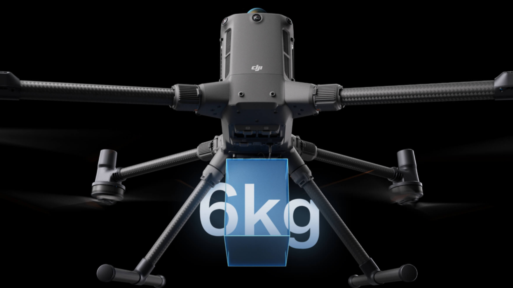
Multi-Payload, Multi-Aplikasi

Dengan kapasitas payload hingga 6 kg, Matrice 400 mendukung konfigurasi gimbal bawah tunggal atau ganda, serta konektor gimbal ketiga di bagian bawah. Empat port eksternal E-Port V2 memungkinkan pemasangan hingga 7 payload secara bersamaan untuk berbagai kebutuhan operasional

Safe and Reliable Flight

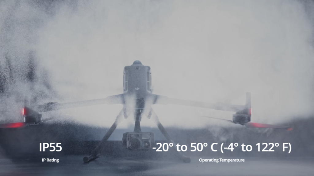
Matrice 400 memiliki perlindungan IP55 yang memungkinkannya beroperasi secara andal di kondisi menantang seperti hujan dan debu. Performa penerbangan tetap stabil pada rentang suhu ekstrem, dari -20°C hingga 50°C, memastikan hasil yang konsisten baik di lingkungan panas maupun dingin

Enhanced Intelligence and Efficiency

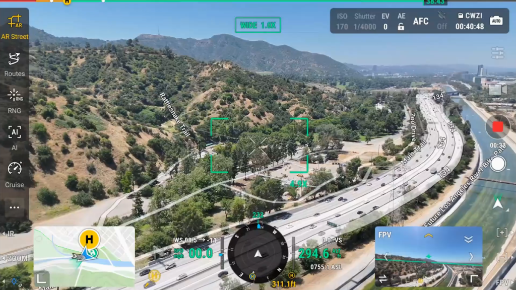
Dengan kamera visual dan thermal Zenmuse H30 Series, Matrice 400 mampu mendeteksi kendaraan, kapal, dan objek untuk operasi SAR maupun penerbangan rutin. Sistem ini mendukung berbagai model deteksi, foto grid resolusi tinggi, serta kemampuan tracking yang andal

SPESIFIKASI

Take Off Weight

Without Batteries : 5020g

With Batteries : 9740g

Max Takeoff Weight

15.8 kg

Dimension

Unfolded: 980×760×480 mm (L×W×H) (with landing gear)

Folded: 490×490×480 mm (L×W×H) (with landing gear and gimbal)

Aircraft carrying case dimensions: 779×363×528 mm (L×W×H)

Max Payload

6 kg

Propeller Size

25 inches

Diagonal Wheelbase

1070 mm

Max Ascent Speed

10 m/s

Max Descent Speed

8 m/s

Max Horizontal Speed (at sea level, no wind)

25 m/s

Max Takeoff Altitude

7000 m

Max Flight Time (no wind)

59 minutes

Max Hover Time (no wind)

53 minutes

Max Flight Distance (no wind)

49 km

Max Wind Speed Resistance

12 m/s

Max Yaw Angular Velocity

Yaw: 100°/s

Max Pitch Angle

35°

Operating Temperature

-20° to 50° C (-4° to 122° F) (without solar radiation)

Global Navigation Satellite System (GNSS)

GPS + Galileo + BeiDou + GLONASS*

RTK GNSS Accuracy

RTK Fix: 1 cm + 1 ppm (horizontal), 1.5 cm + 1 ppm (vertical)

RTK Heading

Supports RTK heading with an accuracy better than 2°

Airborne ADS-B In

Equipped with standard airborne ADS-B In receiver and dual antennas, supporting reception up to 20 km.

Propeller Model

2510F

Beacon

Built into the aircraft

Ingress Protection Rating

IP55

Motor Model

Motor Model

Maximum Payload for Single Gimbal Connector

1400 g

Maximum Payload for Dual Gimbal Connector

950 g

Maximum Payload for Third Gimbal Connector

3 kg for quick-release port, 6 kg for screw lock fastening

Maximum Payload for Zenmuse L3 Gimbal Connector

2100 g

Gimbal Cameras

Zenmuse L3, Zenmuse H30, Zenmuse H30T, Zenmuse L2 and Zenmuse P1

Sensing Type

Omnidirectional binocular vision system (surround view provided by full-color fisheye vision sensors)

Horizontal rotating LiDAR, upper LiDAR, and downward 3D infrared range sensor

Six-direction mmWave radar

Forward

Measurement Range: 0.4-21 m

Detection Range: 0.4-200 m

Field of View (FOV): 90° (horizontal), 90° (vertical)

Backward

Measurement Range: 0.4-21 m

Detection Range: 0.4-200 m

Field of View (FOV): 90° (horizontal), 90° (vertical)

Lateral

Measurement Range: 0.6-21 m

Detection Range: 0.5-200 m

Field of View (FOV): 90° (horizontal), 90° (vertical)

Downward

Measurement Range: 0.5-19 m

The FOV to the front and rear is 160° and 105° to the right and left.

Operating Environment

Forward, Backward, Left, Right, and Upward: Delicate texture on the surface, adequate light.

Downward: The ground has rich textures and sufficient lighting conditions*, with a diffuse reflection surface and a reflectivity greater than 20% (such as walls, trees, people, etc.).

Rotating LiDAR

Standard Measurement Range: 0.5-100 m @ 100,000 lux with 10% reflectivity target

Measurement Range for Power Line: 35 m @ 30° @ 10,000 lux for 21.6 mm steel-core aluminum stranded wire with a relative body tilt angle of 30° to the left and right

Field of View (FOV): 360° (horizontal), 58° (vertical)

Point-Frequency: 520,000 points/second

Laser Wavelength: 905 nm

Eye Safety Level: Class 1 (IEC60825-1:2014), eye-safe

Upper LiDAR (3D ToF)

0.5-25 m at night (reflectivity > 10%)

The FOV to the up and down is 60° and 60° to the right and left.

Downward 3D Infrared Range Sensor

Measurement Range: 0.3-8 m (reflectivity > 10%)

The FOV to the front and rear is 60° and 60° to the right and left.

mmWave Radar

Measurement Range for Power Line:

36 m for a 12mm steel-core aluminum stranded wire

50 m for a 21.6mm steel-core aluminum stranded wire

FOV: ± 45° (horizontal and vertical)

Resolution

1080p

Field of View (FOV)

DFOV: 150°

HFOV: 139.6°

VFOV: 95.3°

Frame Rate

30fps

Night Vision

Starlight Grade

Video Transmission System

DJI O4 Enterprise Enhanced Video Transmission System

Live View Quality

Remote Controller: 3-channel 1080p/30fps

Operating Frequency and Transmitter Power (EIRP)

902-928 MHz: < 30 dBm (FCC), < 16 dBm (MIC)

1.430-1.444 GHz: < 35 dBm (SRRC)

2.4000-2.4835 GHz: < 33 dBm (FCC), < 20 dBm (CE/SRRC/MIC)

5.150-5.250 GHz: < 23 dBm (FCC/CE)

5.725-5.850 GHz: < 33 dBm (FCC), < 14 dBm (CE), < 30 dBm (SRRC)

Max Transmission Distance (unobstructed, free of interference)

40 km (FCC)

20 km (CE/SRRC/MIC)

Max Transmission Distance (with interference)

Strong interference (dense buildings, residential areas): approx. 1.5-6 km

Medium interference (suburban counties, city parks): approx. 6-15 km

Weak interference (open spaces, remote areas): approx. 15-40 km

Max Download Speed

Standard Mode: 80Mbps Downlink

Playback Download: < 25 MBps

Single-Channel Bitrate: ≤ 12 Mbps

Model

TB100

Capacity

20254 mAh

Standard Voltage

48.23 V

Max Charging Voltage

54.6 V

Cell Type

Li-ion 13S

Energy

977 Wh

Weight

4720 ± 20 g

Charging Temperature

5° to 45° C (41° to 113° F)

Discharging Temperature

-20° to 75° C (-4° to 167° F)

Battery Heating

Support

Discharge Rate

4C

Max Charging Power

2C

Low Temperature Charging

Supports low-temperature self-heating charging

Cycle Count

400

Pesan DJI Matrice 400 Sekarang

Scroll to Top